 |
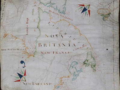
| John Thornton's early map of North America at a time when Britain and France were staking out their claims on the north east corner of the continent and the various Briish settlements and colonies that are now the states of the United States or the provinces of Canada were beginning to emerge. I like the way that Thornton has patriotically written Nova Britania (sic) over New France in much larger letters. On the western side of the map the description of the west side of Hudson's Bay as New South Wales and New North Wales has luckily not survived into modern times otherwise significant confusion would have been caused. With acknowledgement to Lawrence of Crewkerne sale catalogue of 17 January 1ot 551 (see http://www.lawrences.co.uk/ ) |
This map is a reminder of an interesting episode in the seventeenth century when a group of London's leading cartographers sought the protection of the Drapers' Company. They are an important part of our early cartographic history and are today known as the Thames School of Chartmakers.
John Thornton (1641-1708) hydrographer plattmaker (i.e. chart) engraver and publisher was apprenticed to John Burston of the Drapers' Company from 1656 and made a freeman in 1664/5. Other members of the Company include their leader Nicholas Comberford - flourished 1612-20. He was preceded by John Daniel who seems to have started the whole thing by becoming a freemen in 1590. He died in 1649. Thornton's pupil, freeman Joel Gascoyne, produced a series of well known maps of English counties.
Thornton was appointed hydrographer to both the Hudson's Bay and East India Companies. Printed maps of North America by Thornton appear in the Atlas Maritimus of c. 1685 and vol 4 of The English Pilot 1689 and later editions though none are identical to this map. The latter was a very important work as it was a set of accurate charts of the whole world that revolutionised the availability of nautical information for seafarers.
A number of Drapers, including Liveryman Lord Patten of Wincanton, brought this interesting map to Penny Fussell's, our archivist, attention. We do not hold any examples of work by the Draper's mapmakers - except for some of Joel Gascoyne's county maps - but we decided that, entirely on grounds of cost, this was not for our archives. If some of the less rare material appears, for instance maps of the East Indies are more commonly encountered on the market, I think it would be worth acquiring as a memorial of an important part played by our Company in an area completely unrelated to drapery.

No comments:
Post a Comment